The Aceh Information Commission (Komisi Informasi Aceh or KIA) has officially declared that data regarding Right to Cultivate (Hak Guna Usaha or HGU) permits constitutes public information that must be accessible to the general population. This landmark decision was formalized in Document Number 049/XII/KIA-PS-A/2025, marking the conclusion of a high-profile information dispute between the Forest, Nature, and Environment of Aceh Foundation (Yayasan Hutan, Alam dan Lingkungan Aceh, known as HAkA) and the Aceh Provincial Office of the National Land Agency (Badan Pertanahan Nasional or BPN).
The ruling was delivered during a public hearing in Banda Aceh on Wednesday, March 4, 2026. The panel of commissioners, chaired by M. Nasir and supported by members Junaidi and Sabri, concluded that the BPN’s previous refusal to release land concession data lacked sufficient legal standing under Indonesia’s transparency laws. In its final order, the commission instructed the BPN to revoke its "consequence test" document (Nomor B/UP.04.07/101-11/II/2026), which had been used as the primary justification for keeping the land data confidential. Furthermore, the BPN was ordered to conduct a new consequence test in strict accordance with prevailing laws and regulations, which prioritize the public’s right to know over institutional secrecy.
Chronology of the Legal Dispute
The conflict began on October 13, 2025, when HAkA submitted an official request for information to the Head of the BPN Regional Office in Aceh. The environmental organization sought specific documentation regarding the HGU permits held by PT Tegas Nusantara, a plantation company operating in the region. The requested documents were comprehensive, including details on the identity of the permit holders, the designated land use, the expiration dates of the concessions, the total land area, detailed topographical maps, and a copy of the Decree of the Head of BPN Number 34/HGU/BPN/2002, which serves as the legal foundation for the company’s land registration.

In response to the request, BPN Aceh categorized the information as "exempted," arguing that releasing detailed HGU data, particularly maps and specific decree details, could jeopardize corporate interests or national land administration security. This refusal prompted HAkA to escalate the matter to the Aceh Information Commission on December 18, 2025, seeking a resolution through non-litigation adjudication.
Throughout the trial, the panel examined various pieces of evidence and legal precedents. HAkA’s legal team presented significant jurisprudence, including the Indonesian Supreme Court Decision Number 121/K/TUN/2017 and the Central Information Commission (KIP) Decision Number 57/XII/KIP-PS-M-A/2015. Both of these prior rulings established that HGU documents—including maps and coordinates—are public documents because they involve the use of state land and have a direct impact on the livelihoods of local communities.
Legal Basis and Commission Findings
M. Nasir, the Chairman of the Aceh Information Commission, stated during the verdict reading that HAkA, as the applicant, met all legal requirements to access the requested data. As a legally recognized entity with articles of association approved by the Ministry of Law and Human Rights and published in the State Gazette of the Republic of Indonesia, HAkA demonstrated a legitimate interest in the environmental and social governance of the region.
"The information requested is data that can be opened to the public and is entirely within the control of the respondent," Nasir explained. He emphasized that under Law Number 14 of 2008 concerning the Freedom of Public Information (UU KIP), public agencies bear the burden of proof to demonstrate why information should be withheld. In this case, the BPN failed to provide a compelling argument that the disclosure of PT Tegas Nusantara’s HGU data would cause significant harm that outweighs the public interest.

The commission has granted a 14-day window for the BPN to decide whether to accept the ruling or file a further legal challenge. If no action is taken within this period, the decision will become legally binding (inkracht), allowing the applicant to seek a writ of execution from the relevant court to force the release of the documents.
Implications for Land Governance and Transparency
The ruling is seen as a major victory for environmental activists and local communities who have long struggled against "land grabbing" and encroachment by large-scale plantation companies. Fahmi Muhammad, a member of HAkA’s legal team, welcomed the decision, noting that the lack of transparent HGU data has historically led to lopsided conflicts between villagers and corporations.
"Public access to this data is critical," Muhammad said. "Without official maps and documents, how can communities know where a company’s concession ends and their ancestral land or residential areas begin? For too long, we have relied on unilateral claims from HGU holders and the government, leaving the public in the dark."
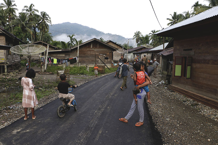
The case of PT Tegas Nusantara is particularly illustrative of these tensions. In areas like Bunin Village, residents depend on clean water, air, and forest resources that are frequently threatened by plantation expansion. When concession boundaries are kept secret, companies can expand their operations into community forests or water catchment areas with little to no accountability.
The Broader Context of Land Conflicts in Aceh
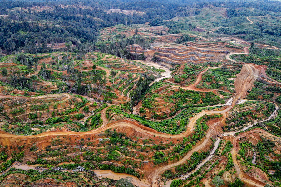
The demand for HGU transparency is not an isolated incident but a response to systemic issues within Aceh’s plantation sector. Data from the Indonesian Forum for the Environment (Walhi) Aceh indicates that the province currently has approximately 1.1 million hectares of plantation land. Of this, roughly 385,000 hectares are managed by large-scale corporations.
Despite the vast scale of these operations, the economic benefits for local communities remain disproportionately low, while environmental and social risks remain high. Afifuddin, Head of the Advocacy and Campaign Division at Walhi Aceh, criticized the culture of secrecy surrounding land permits. "Government agencies consistently hide HGU data under the guise of ‘exempted information.’ This lack of transparency is a primary driver of the agrarian conflicts we see across the province," he stated.
Walhi’s monitoring suggests that many palm oil companies in Aceh operate with a low level of compliance regarding environmental standards. Common issues include:
- Pollution Control: Failure to meet standards for waste management and water pollution.
- Permit Irregularities: Operating without complete environmental permits or utilizing land outside of their designated HGU boundaries.
- Criminalization: Local residents who protest against land encroachment often face legal threats or criminal charges due to the lack of clear, publicly accessible boundary data.
According to Walhi, land conflicts involving plantation companies are currently active in several districts, including Aceh Selatan, Aceh Utara, Aceh Timur, Subulussalam, and Aceh Singkil. The organization has called on the Aceh Government to conduct a comprehensive audit of all HGU permits and to reorganize land distribution to ensure it serves the public interest rather than just corporate profit.
Analysis: Why HGU Transparency Matters
The decision by the Aceh Information Commission sets a vital legal precedent that could reshape land management in Indonesia. The "Right to Cultivate" (HGU) is a lease of state land. Because the land belongs to the state, the terms of its use, the boundaries of the lease, and the identity of the lessee are matters of public concern.
- Conflict Resolution: Clear, accessible maps allow for objective verification of land claims. This can prevent physical confrontations between company security forces and local farmers.
- Environmental Monitoring: Transparency allows civil society organizations to monitor whether companies are clearing land in protected forests or high-conservation-value areas. Without coordinates, satellite monitoring is less effective because the legal boundaries of the concession are unknown.
- Governance and Anti-Corruption: Open data reduces the opportunity for "overlapping permits," where the same piece of land is granted to multiple entities, a common source of corruption and administrative chaos in the Indonesian forestry and plantation sectors.
- Sustainable Investment: For the palm oil industry to be sustainable, it must be traceable. Transparency in HGU data is a prerequisite for international sustainability certifications (such as RSPO or ISPO) and for meeting the "No Deforestation, No Peat, No Exploitation" (NDPE) policies of global buyers.
Conclusion and Future Outlook
The Aceh Information Commission’s ruling represents a significant step toward the "One Map Policy" and the broader goal of open government in Indonesia. By dismissing the BPN’s broad application of the "exempted information" clause, the commission has sent a clear message that land administration must be accountable to the citizens it serves.
As M. Nasir noted, the hope is that this decision will serve as a reference point for future disputes. "We hope this ruling becomes a jurisprudence for any citizen needing HGU data. Public bodies should proactively fulfill these information requests so that such disputes do not need to reach the Commission in the future," he concluded.
The eyes of the environmental and legal communities are now on the BPN. Their response over the coming weeks will determine whether Aceh moves toward a new era of land transparency or remains entangled in the legal battles of the past. For the people of Bunin and other forest-frontier communities, the release of these maps is not just a legal technicality—it is a necessary tool for the protection of their homes, their livelihoods, and their environment.