
The catastrophic flash floods and landslides that ravaged the province of Aceh on Wednesday, November 26, 2025, have left a trail of destruction that extends far beyond the immediate loss of human settlements and agricultural livelihoods. While the initial reports focused on the submerged homes and devastated plantations, a comprehensive analysis by the Forest, Nature, and Environment of Aceh Foundation (HAkA) reveals a much deeper ecological crisis. According to data released in March 2026, the province lost approximately 39,687 hectares of forest cover throughout 2025, a loss that experts directly link to the increased frequency and intensity of natural disasters in the region.
The findings, presented by Lukmanul Hakim, Manager of HAkA’s Geographic Information System (GIS), provide a sobering breakdown of the drivers behind this environmental degradation. Of the nearly 40,000 hectares lost, 24,372 hectares were attributed to natural factors—primarily landslides triggered by extreme rainfall—while 15,230 hectares were the result of direct human intervention. This data suggests a dangerous feedback loop where human-induced forest fragmentation weakens the landscape’s resilience, making it more susceptible to "natural" collapses during the monsoon season.
The 2025-2026 Aceh Environmental Crisis: A Chronology of Disaster
The timeline of the current crisis traces back to the final quarter of 2025. Between November and December of that year, Aceh experienced a series of hydro-meteorological anomalies. While seasonal rains are expected, the intensity of the downpours during this period exceeded historical averages, leading to widespread soil saturation in the highlands.
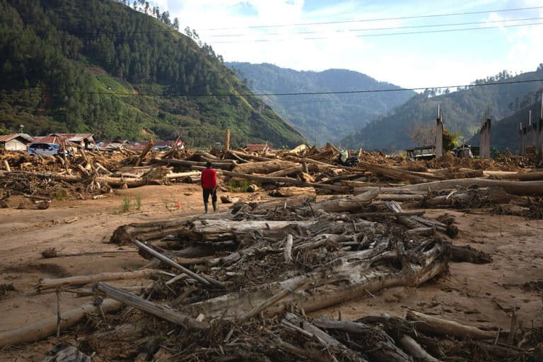
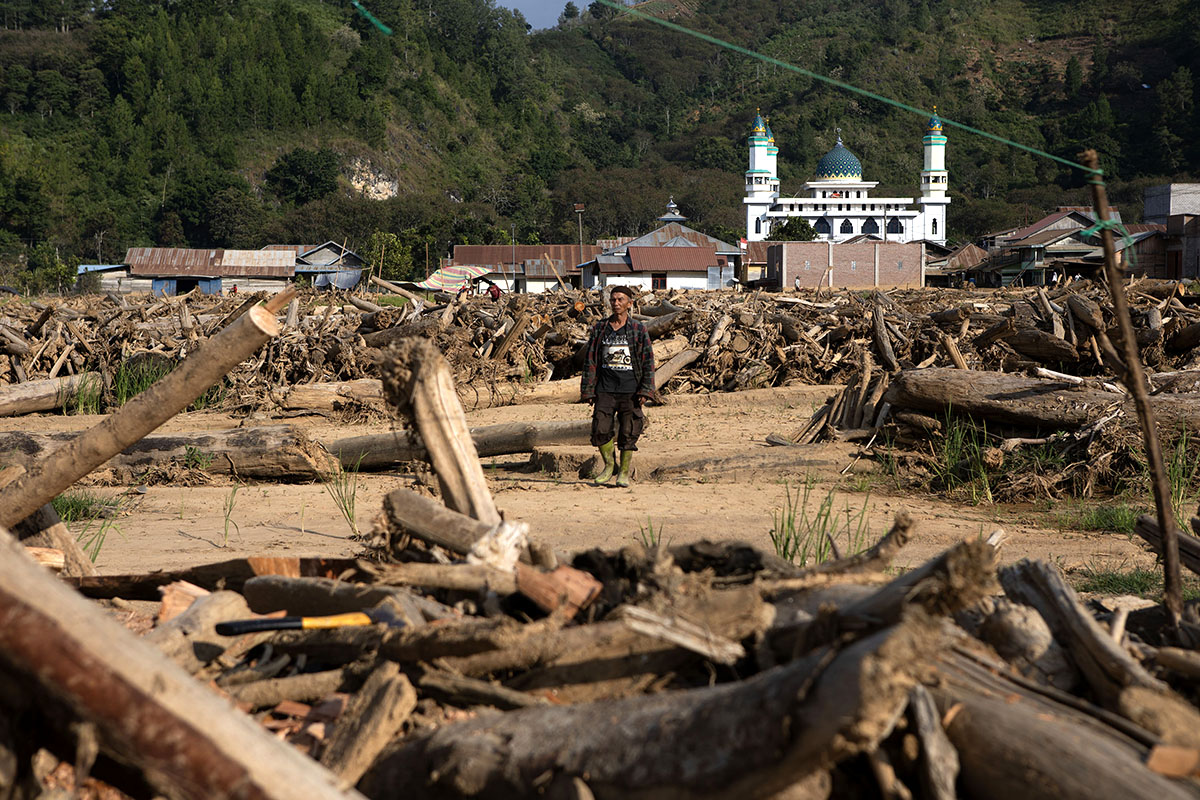
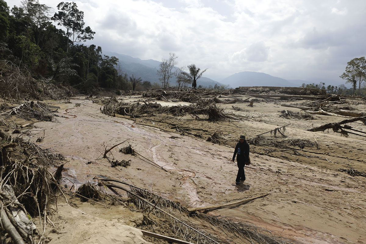
On November 26, 2025, the situation reached a breaking point. Flash floods carrying massive debris—including boulders and large timber—swept through residential areas and agricultural heartlands. In districts like Central Aceh and Bener Meriah, the floods were accompanied by landslides that severed vital transport links and buried entire villages. By January 2026, reports emerged that dozens of villages had effectively disappeared, either buried under mud or rendered uninhabitable by the shifting course of rivers.
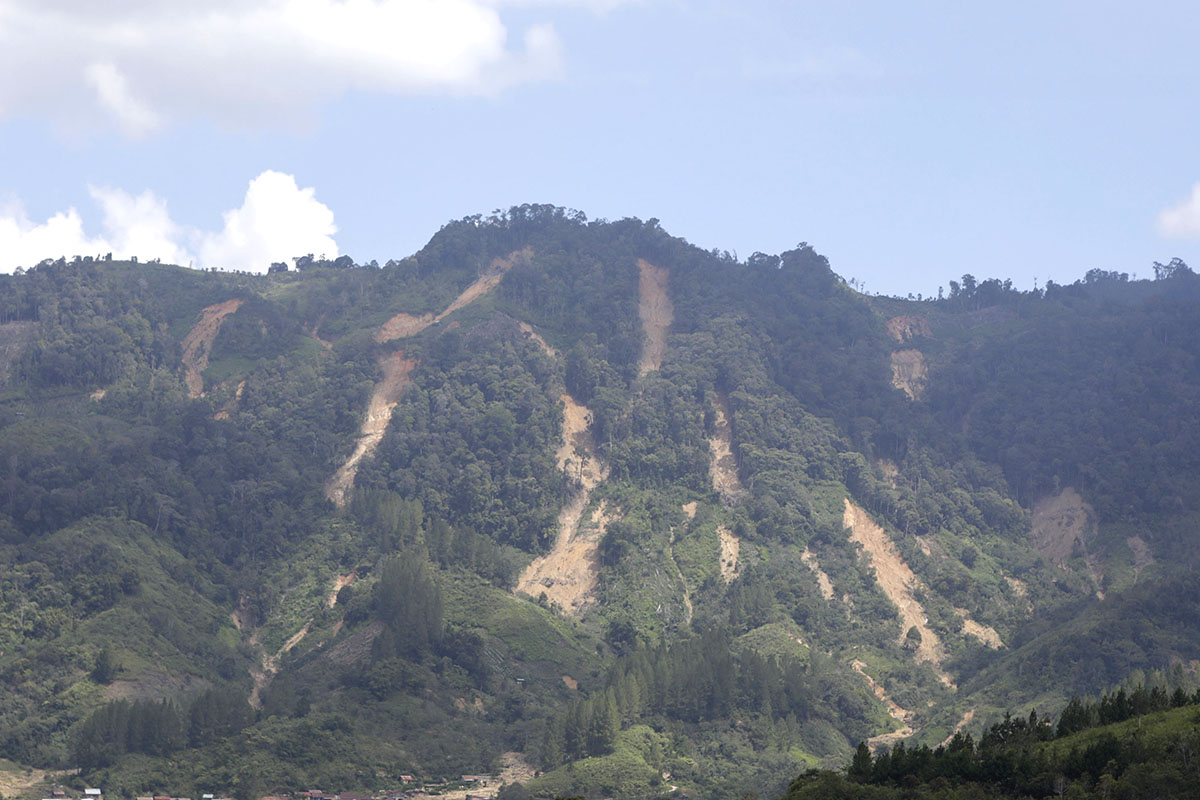
Lukmanul Hakim noted that the vast majority of "natural" forest loss was recorded during these final two months of 2025. Landslides did not only occur in degraded areas but also struck primary forest zones. However, the impact was significantly more severe in areas that had been previously disturbed by road construction, logging, or the conversion of land for plantations. What were once lush, vegetated slopes transformed into scars of exposed earth and debris tracks that channeled mud and timber into the river systems below.
Detailed Statistical Analysis of Forest Loss by Region
The HAkA analysis highlights specific "hotspots" where forest loss has reached critical levels. The data shows that the burden of deforestation and environmental collapse is not evenly distributed across the province, with certain districts suffering disproportionately due to a combination of geography and land-use policy.
- East Aceh (Aceh Timur): This district recorded the highest total loss of forest cover in 2025, losing 8,564 hectares. The breakdown is particularly telling: 7,103 hectares were lost to natural causes (landslides and flooding), while 1,431 hectares were lost to anthropogenic or human-driven activities. The high rate of natural loss here suggests that the mountainous terrain of East Aceh has reached a tipping point of instability.
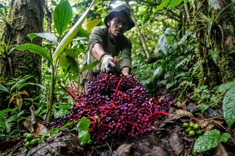
- Central Aceh (Aceh Tengah): Known for its high-altitude coffee plantations, this region lost 6,910 hectares of forest cover. Approximately 5,525 hectares were lost to natural factors, and 1,385 hectares were attributed to human activity. The destruction in Central Aceh has had a profound impact on the local economy, as seen in the devastation of coffee gardens in villages like Toweran and Antara.
- South Aceh (Aceh Selatan) and Nagan Raya: These districts led the province in human-driven deforestation. South Aceh saw 2,195 hectares of forest cleared by human activity, while Nagan Raya followed closely with 2,130 hectares. In these regions, the expansion of monoculture plantations, particularly palm oil, remains a primary driver of forest loss.
The fragmentation caused by road networks and small-scale land clearing has fundamentally altered the soil structure. As Lukman explained, when a forest is "broken" by a road or a clearing, the integrity of the root systems that hold the soil together is compromised. This makes the surrounding "intact" forest far more vulnerable to sliding when heavy rains hit, compared to a continuous, undisturbed forest canopy.
Official Government Response and Data Integration
The technical precision of HAkA’s reporting has drawn praise from government officials, highlighting a rare moment of synergy between civil society and state agencies. Muhammad Yazid, Head of the Forest Resources and Environmental Management Section at the Forest Area Consolidation Center (BPKH) XVIII, acknowledged that the government currently lacks the infrastructure to produce such rapid-response ecological data.

"Only two months after the disaster, HAkA was able to calculate the loss of forest cover with such a comprehensive method," Yazid stated during a briefing in late February 2026. He confirmed that this data would be integrated into the national and regional technical databases to inform future land-use policies.
Yazid also pointed out a crucial distinction between deforestation in Aceh and other Indonesian regions like Kalimantan. In Kalimantan, forest loss is often driven by large-scale industrial logging and massive corporate concessions. In Aceh, however, the landscape has been governed by a logging moratorium since 2007, which successfully halted most large-scale corporate timber extraction.
The current threat in Aceh comes from "Other Use Areas" (APL). Approximately 230,000 hectares of Aceh’s natural forests are located within these APL zones, which are not legally classified as "protected forest" and can be utilized for community plantations or infrastructure. "This is a major cause of deforestation," Yazid explained. "While these areas are legally available for utilization, the environmental impact of clearing them is often overlooked until a disaster occurs."
Structural Roots of the Crisis: The Critique of Monoculture
Environmental experts argue that blaming "extreme weather" or "climate change" alone is an oversimplification that allows policymakers to avoid addressing structural failures. Rudi Putra, a Goldman Environmental Prize winner and Strategic Advisor for the Leuser Conservation Forum (FKL), emphasized that the root of the problem lies in the loss of ecosystem function.
Aceh theoretically possesses 3.5 million hectares of forest, a vast area that should be sufficient to regulate the region’s water cycle and protect against floods. However, Rudi estimates that the "functional" forest cover—forest that is dense and healthy enough to provide ecosystem services—has dropped below 3 million hectares.
"When the forest is gone, there is nothing left to absorb the water, hold the soil, or regulate the flow of the rivers," Rudi said. He highlighted a generational shift in how land is managed. Historically, Acehnese community gardens (kebun) resembled forests, featuring a mix of durian, jengkol, petai, and sugar palms. These diverse systems acted as secondary forests, with deep root systems that anchored the soil.

Today, these diverse gardens have been largely replaced by monoculture crops, primarily oil palm. While palm oil provides immediate economic returns, it offers virtually no ecological protection. The shallow root systems of oil palms cannot hold the soil on steep slopes, and the lack of undergrowth means that rainwater runs off the surface rather than being absorbed into the ground.
The Erosion of Traditional Wisdom and River Protections
Another critical factor in the 2025-2026 disaster is the violation of traditional Acehnese land-use laws. In Acehnese custom (Adat), it is strictly forbidden to clear land within 50 meters of a small stream or 100 meters of a major river. These riparian buffers are essential for preventing bank erosion and filtering runoff.
"Now, those rules are treated as if they never existed," Rudi lamented. The encroachment of plantations right up to the water’s edge has removed the natural ‘brakes’ of the river system. When the flash floods of November 2025 occurred, there was no vegetation to slow the water down, allowing it to gain the velocity and volume necessary to destroy bridges and homes.
Furthermore, many of the areas hit hardest by landslides in 2025 were former Forest Concession (HPH) sites from decades ago. These areas were logged extensively and then abandoned without proper restoration. Many were eventually converted into palm oil plantations, leaving the land in a permanently weakened state.
The Path Toward Ecological Recovery
Despite the grim data, environmental leaders like Panut Hadisiswoyo, founder of the Orangutan Information Centre (YOSL-OIC), believe that recovery is still possible if there is a fundamental shift in mindset. Panut expressed a mix of "anxiety and optimism," noting that while the warnings of environmentalists have often been dismissed as "gimmicks" in the past, the sheer scale of the 2025 disaster has made the reality of ecological collapse impossible to ignore.
"The forest is a single ecological unit," Panut said. "You cannot damage one part and expect the rest to remain healthy. This disaster is a reflection of the long-term loss of function due to fragmentation and the climate crisis."
The consensus among experts is that expensive, high-tech engineering projects are not the only solution to Aceh’s flooding problems. Instead, they advocate for "natural restoration." Rudi Putra emphasized that nature has a remarkable ability to heal itself if human pressure is removed. "Restoration is not necessarily expensive," he noted. "The forest can restore itself; we just need to protect it from further disturbance and allow the natural vegetation to return."
As Aceh moves through 2026, the provincial government faces a critical choice: continue with the expansion of monoculture and infrastructure in sensitive APL zones, or implement a rigorous ecological recovery plan that prioritizes forest connectivity and riparian protection. The data from HAkA serves as a final warning that the province’s environmental buffer has worn thin, and the costs of further inaction will be measured in more than just hectares of lost trees, but in the very survival of the communities that call Aceh home.