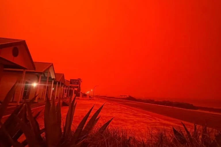
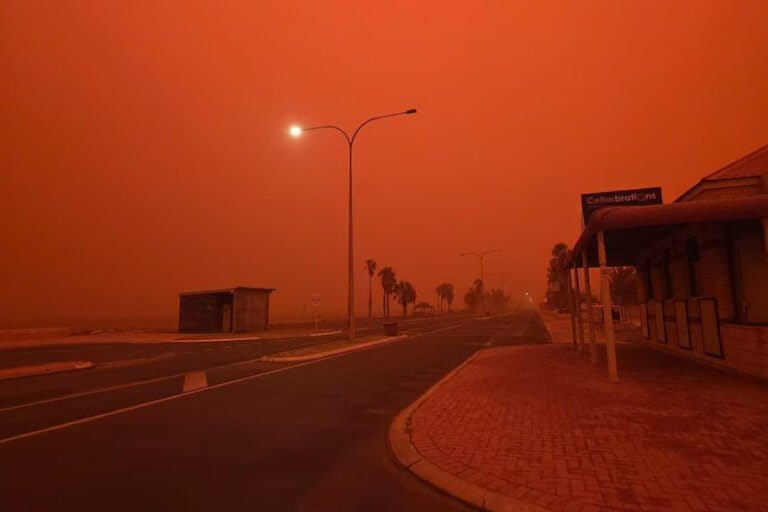
The remote coastal community of Shark Bay, Western Australia, recently became the epicenter of a global media sensation as a rare atmospheric phenomenon turned the sky a deep, visceral shade of crimson. The visual spectacle, which residents described as resembling a scene from a post-apocalyptic film, was captured in numerous viral videos and photographs, prompting both awe and concern across social media platforms. While the imagery suggested a supernatural or catastrophic event, meteorologists and environmental scientists have clarified that the "blood-red sky" was the result of a precise alignment of geological, atmospheric, and cyclonic conditions. The event was primarily driven by the approach of Tropical Cyclone Narelle, which acted as a catalyst for one of the most intense dust-scattering events recorded in the region in recent decades.
For the residents of Shark Bay and surrounding Gascoyne towns, the experience was more than just a visual oddity; it was a sensory ordeal. As the sky darkened into a deep ochre and eventually a saturated red, the air became thick with fine particulate matter. Locals reported that the atmosphere felt heavy and abrasive, with fine grains of sand and dust infiltrating homes, stinging eyes, and causing a distinct metallic taste in the throat. The intensity of the color was so profound that automated streetlights triggered in the middle of the day, as the particulate matter effectively blocked out the shorter wavelengths of the solar spectrum, leaving only a haunting, monochromatic red glow to illuminate the landscape.
The Geological Engine: Iron Oxide and the Pilbara Sands
The fundamental cause of the red hue lies in the unique geology of the Australian Outback. Western Australia, particularly the Pilbara and Gascoyne regions, is home to some of the oldest and most mineral-rich crust on Earth. The soil in these areas is exceptionally high in iron oxide, commonly known as rust. Over millions of years, the weathering of iron-rich rocks has produced a fine, powdery sediment that dominates the landscape. Under normal conditions, this soil remains on the ground, held in place by sparse vegetation and crustal stability.
However, the period leading up to the arrival of Tropical Cyclone Narelle was characterized by an intense six-week drought. This prolonged lack of rainfall caused the top layer of the soil to desiccate completely, breaking down into microscopic particles of iron-rich dust. When the peripheral winds of the cyclone began to sweep across the mainland, they acted like a giant vacuum, lifting millions of tons of this red sediment into the troposphere. Tom Gill, a renowned dust specialist from the University of Texas, noted that the concentration of iron oxide in this specific event was among the most extreme ever monitored, providing the "pigment" for the atmospheric canvas that would soon envelop the coast.
Meteorological Dynamics: The Impact of Cyclone Narelle
The role of Tropical Cyclone Narelle was twofold: it provided the mechanical force to lift the dust and the atmospheric "ceiling" to trap and tint the light. As the cyclone moved parallel to the Western Australian coast, its clockwise rotation in the Southern Hemisphere created a powerful offshore-to-onshore wind pattern. These winds traveled over hundreds of kilometers of arid, red-soiled desert before reaching the coastal settlements of Shark Bay.

According to the Bureau of Meteorology (BOM), the timing of the dust’s arrival coincided with the thick leading edge of the cyclone’s cloud deck. This was a critical factor in the visual intensity of the event. Angus Hines, a senior forecaster at the BOM, explained that typically, dust storms occur under clear blue skies, which results in a hazy orange or brown appearance. However, when a massive dust plume is positioned beneath a thick layer of altostratus and nimbostratus clouds, the lighting dynamics change entirely. The clouds act as a massive diffuser, scattering the remaining light evenly across the horizon. This eliminates shadows and creates an immersive environment where the red light appears to emanate from every direction simultaneously, rather than from a single solar source.
The Physics of Light: Why the Sky Turned Red
The transformation of the sky’s color can be explained through the principles of atmospheric scattering, specifically Rayleigh scattering and Mie scattering. Under a clear sky, the Earth’s atmosphere scatters shorter wavelengths of light (blue and violet) more efficiently, which is why the sky typically appears blue. When the atmosphere becomes laden with large particles, such as the dust lifted by Cyclone Narelle, the scattering process shifts.
The iron oxide particles are significantly larger than gas molecules. These particles act as a physical filter, absorbing and scattering the shorter blue and green wavelengths of the visible spectrum before they can reach the surface. Only the longer wavelengths—red, orange, and deep pink—possess the energy required to penetrate the dense curtain of mineral dust. Steve Turton, an Adjunct Professor of Environmental Geography at CQUniversity, noted that the specific mineralogy of the Australian dust further enhanced this effect. The iron oxide does not just scatter red light; it actively reflects it, creating a "feedback loop" of red illumination that intensified as the dust density increased. This resulted in the "blood-red" saturation that was so striking to observers on the ground.
Chronology of the Phenomenon
The event unfolded over a period of approximately 48 hours, following a distinct timeline:
- The Pre-Arrival Phase (Weeks 1-6): Extreme heat and zero precipitation across the Gascoyne and Pilbara regions lead to the total desiccation of surface soils.
- The Approach (Hours 0-12): As Cyclone Narelle moves toward the coast, wind speeds increase to 60-90 km/h in the desert interior. Massive dust walls, known as haboobs, begin to form and merge.
- The Inversion (Hours 12-24): The dust plume reaches the coast, sliding underneath the advancing cloud shield of the cyclone. Visibility in Shark Bay drops from 20 kilometers to less than 500 meters.
- The Peak (Hours 24-30): The sun is completely obscured. The "blood-red" effect reaches its maximum intensity as the deepest part of the dust plume aligns with the thickest cloud cover. This is when the viral images were captured.
- The Washout (Hours 30-48): As the center of the cyclone draws closer, heavy tropical rains begin to fall. The moisture attaches to the dust particles, dragging them out of the atmosphere in a phenomenon sometimes called "blood rain." The air clears rapidly, and the sky returns to a standard grey-blue.
Public Health and Infrastructure Implications
While the visual aspect of the red sky was a marvel of nature, the underlying dust storm presented significant hazards to the local population and infrastructure. Health departments in Western Australia issued urgent warnings during the event, particularly for vulnerable groups. The fine particulate matter (PM10 and PM2.5) found in mineral dust is small enough to be inhaled deep into the lungs. For individuals with pre-existing conditions such as asthma, chronic obstructive pulmonary disease (COPD), or cardiovascular issues, the dust storm posed a life-threatening risk.
In Shark Bay, residents were advised to remain indoors, seal gaps under doors with damp towels, and switch air conditioning units to "recirculate" to prevent the intake of outdoor air. Beyond respiratory concerns, the "grittiness" of the air caused widespread reports of conjunctivitis and throat irritation.
The economic impact was also felt through the grounding of local aviation and the closure of major transport routes. Visibility on the North West Coastal Highway dropped to near-zero levels, leading to the temporary suspension of long-haul trucking operations. Furthermore, the abrasive nature of the mineral dust is known to cause accelerated wear on machinery and vehicle engines, necessitating a massive cleanup and maintenance effort once the storm subsided.
Climate Context and Future Outlook
Environmental scientists are viewing the Shark Bay event as a potential harbinger of shifting climatic patterns in Australia. While dust storms are a natural part of the Australian ecosystem—serving to transport nutrients like iron to the ocean to feed plankton—the frequency and intensity of these events are closely tied to land management and climate cycles.
The increasing prevalence of "megadroughts" in the Australian interior, exacerbated by rising global temperatures, means that the "reservoir" of loose, erodible soil is growing. When these dry conditions meet the volatile energy of a tropical cyclone, the results are increasingly dramatic. Analysts suggest that as the climate warms, the energy available to cyclones like Narelle increases, potentially leading to stronger winds and more significant dust-lifting events.
Professor Steve Turton and other experts emphasize that while the "blood-red sky" is a stunning scientific curiosity, it serves as a visual reminder of the fragility of the arid Australian landscape. The loss of topsoil during such events is a form of land degradation that can take decades to recover.
Conclusion
The blood-red skies of Shark Bay stand as a testament to the raw power of the Australian environment and the complex interplay of atmospheric physics. It was a moment where the "red heart" of the continent was literally lifted into the air, painting the sky with the minerals of the earth. As the dust settled and the rains of Cyclone Narelle washed the landscape clean, the event left behind a wealth of data for scientists to study. For the people of Western Australia, it remains a vivid memory of a day when the world turned red, reminding them of the thin line between a beautiful natural phenomenon and a harsh environmental reality. Through continued monitoring and a deeper understanding of these events, authorities hope to better predict and mitigate the health and safety risks associated with Australia’s increasingly frequent and intense dust storms.