 Bambang Pamungkas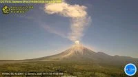
Mount Semeru, the towering stratovolcano situated in the East Java province of Indonesia, experienced a notable volcanic eruption on the morning of September 30, 2026. The geological event sent a thick column of ash soaring approximately one thousand meters above its summit, reigniting safety concerns across the region and prompting authorities to maintain a strict vigilance protocol. The Geological Agency under the Ministry of Energy and Mineral Resources (Kementerian ESDM) officially confirmed the eruption, providing real-time data regarding the seismic activity, visual observations, and immediate safety recommendations for residents, farmers, and travelers in the surrounding districts.
As one of Indonesia’s most active and closely monitored volcanoes, Semeru’s latest episode underscores the persistent geological hazards facing communities residing along its volatile slopes. With the alert status remaining firmly at Level III, or Siaga (Standby), disaster mitigation agencies, local government units, and emergency response teams have intensified monitoring efforts and reinforced safety perimeters to prevent casualties and mitigate potential property damage.
Chronology and Chronological Breakdown of the Eruption Event
The sequence of events unfolded rapidly during the early morning hours of September 30, 2026. According to the official monitoring post operated by the Center for Volcanology and Geological Hazard Mitigation (PVMBG) under the Geological Agency, the eruption occurred precisely at 08:02 Western Indonesia Time (WIB).
Prior to the main eruption pulse, continuous monitoring instruments recorded micro-seismic shifts typical of fluid movement within the volcanic conduit. At 08:02 WIB, the pressure culminated in a sudden, explosive release of gas, ash, and volcanic material. The eruption column was visually confirmed to reach an estimated height of 1,000 meters above the crater peak, placing the top of the ash plume at approximately 4,676 meters above sea level.
Eyewitness accounts and visual monitoring equipment detailed the appearance of the eruption plume. The column displayed a dense, heavy texture, shifting in color from stark white to dark grey as denser particulate matter was expelled. Influenced by prevailing atmospheric conditions at that altitude, the thick ash cloud drifted predominantly toward the northeast, dusting vegetation, rooftops, and agricultural lands in the downwind sectors.
Instrumental recordings captured by seismographs at the observation post provided quantitative metrics of the explosion. The eruption registered a maximum amplitude of 22 millimeters and maintained a sustained tremor duration of approximately 2 minutes and 35 seconds. Although relatively short in duration, the energy output was sufficient to project volcanic materials significantly high into the atmosphere and trigger localized safety protocols across Lumajang and Malang regencies.
Comprehensive Safety Recommendations and Exclusion Zones
In direct response to the September 30 eruption and the ongoing assessment of volcanic behavior, the Geological Agency of the Ministry of Energy and Mineral Resources issued an updated set of mandatory safety recommendations. These guidelines are designed to protect local populations from primary and secondary volcanic hazards, which include pyroclastic flows, lava avalanches, and cold lahars.
First, authorities have strictly prohibited any form of human activity within the southeastern sector along the Besuk Kobokan drainage basin, extending up to a distance of 13 kilometers from the peak, which serves as the primary eruption center. Beyond this 13-kilometer threshold, the agency has mandated that individuals must maintain a safety buffer of at least 500 meters from the riverbanks (sempadan sungai) along Besuk Kobokan. This precaution is vital because the river valley serves as a natural pathway for potential expansions of incandescent pyroclastic flows and lahar floods, which can travel as far as 17 kilometers downstream from the summit.
Second, a complete prohibition remains in effect regarding any public or private activities within a strict five-kilometer radius from the active crater or summit of Mount Semeru. This zone is classified as an extreme hazard area due to the high probability of ballistic projectile ejections, including incandescent rock fragments, lapilli, and volcanic bombs propelled directly from the vent during explosive phases.
Third, residents and local authorities are urged to maintain high vigilance regarding the secondary hazards associated with the rainy season and loose volcanic material deposited on the upper slopes. The areas surrounding river valleys originating from the peak—specifically Besuk Kobokan, Besuk Bang, Besuk Kembar, and Besuk Sat—as well as smaller tributaries linked to the Besuk Kobokan system, face heightened risks of cold lahar flows (lahar dingin) whenever heavy precipitation occurs in the upper catchment areas.
Geological Profile and Background Context of Mount Semeru
Mount Semeru, locally known as Mahameru (The Great Mountain), stands as the highest volcano on the island of Java and one of the most iconic peaks in the Indonesian archipelago. Rising 3,676 meters above sea level, it is part of the Tengger volcanic complex located in the border region between Malang and Lumajang regencies in East Java. Semeru is renowned for its frequent, almost continuous stermban-type activity, characterized by small-to-moderate explosions occurring at regular intervals from its active summit crater, known as Jonggring Saloka.
The geological makeup of Semeru consists primarily of alternating layers of hardened lava, tephra, pumice, and volcanic ash, built up over centuries of persistent eruptive cycles. The volcano’s tectonic setting is dictated by the subduction of the Indo-Australian Plate beneath the Eurasian Plate, a continuous geological process that generates high levels of seismicity and volcanism throughout the Sunda Arc.
Historically, Semeru has maintained a record of significant eruptive episodes. Major historical events include severe sector collapses, pyroclastic surges, and extensive lahar floods that have impacted surrounding settlements. The catastrophic eruption of December 4, 2021, remains vividly etched in the public memory, having caused substantial structural damage, displacement of thousands of residents, and loss of life in the Lumajang regency. That event dramatically shifted the national focus toward enhanced early warning systems, community preparedness, and the establishment of robust evacuation corridors.
Official Responses and Institutional Preparedness
Following the September 30 eruption, disaster management agencies at both the national and regional levels mobilized swiftly to assess conditions and ensure operational readiness. The National Disaster Management Agency (BNPB), in coordination with the Regional Disaster Management Agency (BPBD) of East Java and Lumajang, reviewed emergency response frameworks to guarantee seamless communication channels between volcanologists, local governments, and vulnerable communities.
Local observation posts continue to operate on a 24-hour schedule, utilizing advanced seismic sensors, tiltmeters, and high-resolution thermal cameras to monitor subterranean pressure, ground deformation, and surface temperature anomalies. Data collected by the Geological Agency is transmitted in real-time to central processing servers in Bandung, allowing scientists to detect subtle changes in volcanic behavior and issue timely warnings should the alert status require further escalation.
Community resilience programs, established in the wake of previous major eruptions, were activated as a precautionary measure. Local volunteers, village disaster response groups (Destana), and search and rescue (SAR) units conducted localized patrols to ensure that residents residing near the designated exclusion zones adhered strictly to the government’s safety advisories. Public information campaigns were also disseminated via local radio networks and mobile messaging platforms to remind farmers and sand-mining operators working along the riverbeds to evacuate immediately upon observing any signs of dark plumes or abnormal rumbling sounds from the summit.
Socioeconomic Implications and Agricultural Impact
The persistent activity of Mount Semeru carries significant socioeconomic implications for the populations inhabiting its fertile foothills and valleys. The volcanic soils of East Java are exceptionally rich in minerals, providing ideal conditions for intensive agriculture, horticulture, and livestock farming. Consequently, thousands of farmers rely on the lands surrounding Semeru for their daily livelihoods, cultivating crops such as chili peppers, cabbages, corn, and coffee.
However, volcanic eruptions and subsequent ashfall present a dual-edged sword for the regional economy. While mineral-rich ash enhances long-term soil fertility, immediate ash emissions can devastate standing crops, choke vegetation, damage greenhouse structures, and contaminate vital water sources for livestock. The agricultural sector in Lumajang and Malang regencies frequently faces temporary setbacks following moderate eruptions like the one recorded on September 30, requiring rapid intervention from agricultural extension services to assist farmers with crop rinsing, protective sheeting, and livestock feed distribution.
Furthermore, infrastructure such as bridges, rural roads, and irrigation channels situated along river valleys remain vulnerable to abrasion and blockage by lahar sediment. The maintenance of sabo dams—engineered structures designed to trap debris and slow down lahar flows—plays a crucial role in safeguarding downstream villages and vital transportation links. Local economic planning increasingly incorporates comprehensive risk assessments, balancing the agricultural benefits of the volcanic environment with the imperative need for robust infrastructure protection and disaster-resilient community development.
As monitoring operations continue and the Level III Siaga status remains enforced, authorities reiterate the importance of public discipline and adherence to scientific recommendations. The Geological Agency and disaster mitigation partners will continue to issue periodic updates as new data emerges from the observation network, ensuring that all stakeholders remain informed and prepared in the face of ongoing geological dynamism in East Java.