Jakarta, CNBC Indonesia – Indonesia’s Geological Agency, operating under the Ministry of Energy and Mineral Resources (ESDM), has undertaken a comprehensive mapping effort to identify potential secondary hazards, including ground cracks and liquefaction, following a powerful Magnitude 6.7 earthquake that struck Central Sulawesi. This critical assessment is founded on in-depth subsurface geophysical analysis, which has pinpointed intense activity within the complex Palolo Graben Structure. The agency’s findings underscore a heightened risk profile for the affected region, necessitating urgent attention to hazard mitigation and public safety protocols.
The earthquake, which registered at a local magnitude of 6.7, had its epicenter on land, approximately 42 kilometers southeast of Palu City. Geological analysis indicates that the temblor was characterized by a normal fault mechanism, signifying that the earth’s crust pulled apart, causing one block to slide downward relative to the other. Following the main shock, field teams have been diligently monitoring an extensive sequence of aftershocks, with over 150 events recorded by June 18, 2026. These aftershocks have varied in strength, ranging from Magnitude 2.5 to 5.1, reflecting an ongoing release of tectonic stress and a complex geological response to the primary seismic event.
The Geological Agency highlighted the intricate nature of the region’s geology, stating via its official Instagram account on Saturday, June 20, 2026, "The occurrence of a main earthquake followed by numerous aftershocks indicates complex geological conditions, characterized by diverse lithology in terms of rigidity and hardness, as well as an intensively developed distribution of geological structures in the affected area." This complexity amplifies the potential for cascading hazards, as different rock and soil types respond distinctly to seismic forces, and existing fault lines can become reactivated or trigger new movements. The agency further emphasized the potential for "secondary hazards such as ground cracks, land subsidence, landslides, and liquefaction," urging the public to exercise extreme caution and to avoid steep slopes or cliff areas prone to landslides.
Understanding the Seismic Event: Magnitude Discrepancies and Tectonic Mechanisms
While the local Indonesian assessment reported a Magnitude 6.7, international seismological institutions provided slightly differing parameters, a common occurrence due to variations in sensor networks, data processing, and algorithms used for calculating earthquake magnitudes. The United States Geological Survey (USGS), for instance, recorded a Magnitude 6.99 at a depth of 11.5 kilometers, while the German Research Centre for Geosciences (GFZ) reported a Magnitude 6.66 at a shallower depth of 10 kilometers. Despite these numerical differences, the impact on the surface was profoundly strong, with shaking intensity reaching IX on the Modified Mercalli Intensity (MMI) scale. This severe intensity, indicative of violent shaking capable of causing considerable damage to well-built structures and extensive damage to ordinary buildings, was significantly amplified by the prevalence of soft soil conditions in densely populated areas.
Crucially, the Geological Agency’s analysis firmly attributed the earthquake’s mechanism to a normal fault system within the Palolo Graben. This finding directly refutes any speculation linking the event to the more widely known and historically active Palu-Koro or Sausu strike-slip faults, which involve horizontal motion along the fault plane. "Analysis shows a normal fault mechanism triggered by the Palolo Fault (graben), not the Palu-Koro or Sausu faults which have a strike-slip mechanism. We also found no indication that the Palu-Koro Fault was activated by this earthquake," the agency clarified. This distinction is vital for understanding the specific tectonic forces at play and for guiding future hazard assessments and mitigation strategies for the various fault systems crisscrossing Central Sulawesi.
Distinguishing Sea Level Changes from Tsunami
A key clarification issued by the Geological Agency concerned observations of receding seawater in Palu Bay immediately following the main shock. The agency unequivocally stated that the observed lowering of sea level and subsequent wave activity were not indicative of a tsunami. Instead, these phenomena were attributed to "the effect of changes in the physical condition of the coast due to the strong shaking, including land subsidence." This explanation is crucial to prevent public panic and misinformation, especially in a region that tragically experienced a devastating tsunami in 2018. The agency reiterated, "It is not an indication of a tsunami." Land subsidence, where the ground surface sinks due to compaction or tectonic deformation, can indeed cause localized changes in coastal morphology and apparent sea level fluctuations.
Detailed Examination of Physical Impacts and Secondary Hazards
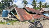
The on-the-ground physical impacts of the earthquake provided tangible evidence of the intense ground motion and its destructive potential. Significant land subsidence was observed, particularly in Palu Bay, which led to the temporary retreat of seawater. This phenomenon, distinct from a tsunami, is a direct consequence of the ground beneath the coastal areas compacting or settling downwards.
Beyond coastal changes, the earthquake also triggered widespread slope instability. In the vicinity of Mount Kamarora, the powerful tremors unleashed landslides, causing substantial material to slide down the slopes. Furthermore, critical infrastructure was affected, with notable damage to the access road leading to the Napu region, where sections of the road experienced slumping and collapse. These landslides and ground failures pose immediate dangers and complicate relief efforts, requiring extensive engineering assessments for repair and rebuilding.
The potential for liquefaction remains a paramount concern, particularly in regions that fall within medium to high-risk Disaster Prone Areas (Kawasan Rawan Bencana, KRB). The Geological Agency highlighted that the affected areas are characterized by soil classifications ranging from soft rock to very soft soil (Vs30 classes C, D, and E). Vs30 refers to the average shear wave velocity in the top 30 meters of a site, and lower values (C, D, E) indicate softer, less stable ground highly susceptible to amplification of seismic waves and liquefaction. This combination of intense ground shaking (MMI IX) and highly liquefiable soil conditions creates a significant risk in densely populated areas. The agency specifically identified Kabupaten Sigi, Palu City, Kabupaten Parigi Moutong, and parts of Kabupaten Poso as areas with high liquefaction potential. Liquefaction occurs when saturated granular soil temporarily loses its strength and stiffness and behaves like a liquid during an earthquake, leading to devastating structural damage and ground deformation.
Tectonic Setting and Historical Context of Central Sulawesi
Central Sulawesi lies within one of the most tectonically active and complex regions globally, situated at the nexus of several major tectonic plates: the Eurasian, Indo-Australian, Philippine Sea, and Pacific plates. This intricate interaction gives rise to numerous active fault systems, including the well-known Palu-Koro fault, the Matano fault, and various others that crisscross the island. The Palolo Graben, identified as the source of the recent earthquake, is a significant geological structure within this complex framework, characterized by extensional forces leading to normal faulting.
The region has a history of powerful earthquakes, most notably the Magnitude 7.5 earthquake and subsequent tsunami and liquefaction event that devastated Palu and Donggala in September 2018. While the recent M 6.7 event had a different fault mechanism (normal fault vs. strike-slip in 2018) and did not trigger a tsunami, the memory of the 2018 disaster profoundly shapes public awareness and preparedness efforts. The recurrence of strong earthquakes underscores the persistent seismic hazard in Central Sulawesi and highlights the critical need for robust disaster resilience strategies. Understanding the distinct mechanisms of different faults is key to refining hazard maps and developing targeted mitigation measures.
Official Recommendations and Future Preparedness
In light of these findings, the Geological Agency has issued a series of crucial recommendations aimed at enhancing public safety and long-term resilience. Foremost among these is the imperative for all new and existing buildings in hazard-prone areas to be designed and retrofitted according to stringent earthquake-resistant construction principles. This includes not only structural integrity but also the provision of clear and accessible evacuation routes within buildings and communities.
The agency also stressed the importance of immediate post-earthquake actions. Residents are strongly advised to meticulously inspect the structural integrity of their homes and workplaces for any cracks or damage before re-entering, to prevent injuries from potential collapses during aftershocks. Beyond individual actions, the agency emphasized the critical role of official communication channels, urging the public to "always follow directions and information from local BPBD (Regional Disaster Management Agency) officers, and remain vigilant regarding the possibility of aftershocks." This includes not being swayed by "irresponsible information regarding earthquakes or tsunamis" and actively combating the spread of hoaxes, which can lead to unnecessary panic or, conversely, dangerous complacency.
The BPBD and BNPB (National Disaster Management Agency), along with local government bodies, play a pivotal role in coordinating disaster response, providing accurate information, managing evacuations, and delivering humanitarian aid. Their guidance is paramount during and after such events. The Geological Agency concluded its public advisory by urging calm but persistent vigilance: "Stay calm, there is no need to panic, but you must remain vigilant. Because aftershocks are normal, avoid cracked buildings. Do not easily believe rumors or hoaxes, and always refer to official information from BPBD, BNPB, and local governments."
Broader Implications for Regional Resilience and Development
The recent Central Sulawesi earthquake serves as a stark reminder of Indonesia’s inherent vulnerability to seismic hazards and carries significant implications for regional development, infrastructure planning, and public awareness. The extensive mapping of secondary hazards, particularly liquefaction potential, provides invaluable data for urban planners and policymakers. It necessitates a re-evaluation of land-use zoning, especially in areas with very soft soil, to minimize risks to future developments. Investing in resilient infrastructure, including roads, bridges, and utilities, capable of withstanding severe shaking and ground deformation, is not merely an engineering challenge but an economic imperative for sustainable growth.
Furthermore, the event underscores the continuous need for public education and preparedness programs. Regular earthquake drills, clear communication strategies for immediate post-disaster actions, and sustained campaigns to raise awareness about diverse secondary hazards like liquefaction and landslides are essential. Empowering communities with knowledge and practical skills to respond effectively can significantly reduce casualties and property damage. The collaborative efforts between scientific institutions like the Geological Agency, disaster management bodies, and local communities are crucial for building a more resilient Central Sulawesi, capable of adapting to and mitigating the recurrent threats posed by its dynamic geological environment. The ongoing scientific monitoring and research will continue to refine our understanding of these complex phenomena, enabling more precise hazard assessments and better-informed decisions for safeguarding lives and livelihoods in this tectonically active region.