
Jakarta, Indonesia – Indonesia is facing a heightened risk of major earthquakes following the release of the updated Earthquake Source and Hazard Map 2024, which reveals a significant increase in identified megathrust zones, now totaling 14 active points across the archipelago. This revised map paints a more concerning picture than its 2017 predecessor, with tighter risk contours indicating a greater potential for seismic activity in various regions. The implications of this update have drawn the attention of international scientists, notably Professor Kosuke Heki from Hokkaido University, who observes striking geological similarities between Indonesia’s seismic landscape and Japan’s highly active Nankai Trough.
Understanding Indonesia’s Tectonic Tapestry
Indonesia sits squarely on the "Ring of Fire," a horseshoe-shaped belt around the Pacific Ocean characterized by frequent earthquakes and volcanic eruptions. This intense geological activity is a direct consequence of the collision and subduction of major tectonic plates. The Indo-Australian Plate is subducting beneath the Eurasian Plate along the Sumatra-Java Trench, while the Pacific Plate and Philippine Sea Plate interact with the Eurasian and Australian plates in the eastern parts of the archipelago. These complex interactions create numerous subduction zones, where one tectonic plate slides beneath another, leading to the formation of megathrust faults – the largest fault zones on Earth. These faults are capable of generating the most powerful earthquakes and tsunamis.
The 2004 Indian Ocean earthquake and tsunami, which devastated Aceh and surrounding regions, serves as a stark historical reminder of the immense destructive power of megathrust events in the Indonesian context. That event, triggered by a rupture along the Sunda megathrust, underscored the critical need for continuous research, monitoring, and robust mitigation strategies. The updated 2024 map is a direct response to this ongoing imperative, incorporating new data and methodologies to provide a more accurate assessment of the nation’s seismic vulnerabilities.
The 2024 Map: A Deeper Dive into Risk
The updated Earthquake Source and Hazard Map 2024 represents a critical evolution in Indonesia’s understanding of its seismic threats. The increase from previous assessments reflects advances in geological surveying, seismological data analysis, and improved computational modeling. The "tighter risk contours" mentioned in the report signify that areas previously considered at moderate risk are now seen as having a higher probability of experiencing significant ground shaking, or that the potential magnitude in certain areas has been revised upwards. This refinement is crucial for urban planning, infrastructure development, and disaster preparedness across the nation.
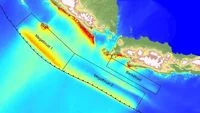
Among the newly identified or re-evaluated zones, several stand out due to their immense potential for devastating quakes. The Aceh-Andaman Megathrust is now recognized as having the largest maximum potential magnitude, estimated at a staggering 9.2. This zone extends from the Andaman Islands down along the coast of Sumatra, a region historically prone to major seismic events. The Java Megathrust, running beneath the southern coast of Java, is another critical area, with a potential magnitude of up to 9.1. Further to the west, the Mentawai-Siberut, Mentawai-Pagai, and Enggano megathrust segments each hold the potential for earthquakes up to magnitude 8.9. These figures are not mere statistics; they represent immense energy capable of unleashing catastrophic destruction, including widespread ground shaking, liquefaction, landslides, and devastating tsunamis.
Japanese Expertise and the Nankai Trough Analogy
Professor Kosuke Heki’s observations, shared during his visit as a Visiting Researcher at the National Research and Innovation Agency (BRIN) in late December 2025, highlight the global relevance of Indonesia’s seismic challenges. His comparison of Indonesia’s geological characteristics to the Nankai Trough off the coast of Japan is particularly insightful. The Nankai Trough is a highly active subduction zone known for generating mega-earthquakes with a relatively predictable recurrence interval, typically every 50 to 100 years.
"We understand that magnitude 8 earthquakes in Japan occur at intervals of approximately 50 to 100 years. This has been our classical view before the occurrence of major earthquakes," Professor Heki stated, emphasizing the long-term perspective necessary for understanding these phenomena. This long-term monitoring is crucial because, while the exact timing of a major earthquake remains elusive, the geological processes that lead to them are continuous and measurable.
Heki stressed the paramount importance of sustained, long-term monitoring of crustal deformation. He specifically advocated for the widespread deployment and integration of Global Navigation Satellite System (GNSS) technology, along with advanced seafloor geodesy measurements. GNSS, which includes systems like GPS, GLONASS, Galileo, and BeiDou, utilizes a network of satellites to precisely measure minute movements of the Earth’s surface. By tracking changes in the positions of ground-based receivers over time, scientists can detect the subtle deformation of the Earth’s crust, providing crucial data on the accumulation of tectonic stress.
Seafloor geodesy complements GNSS by extending these measurements to the submerged parts of the plate boundaries, which are often where the most significant strain accumulates. This involves deploying instruments on the seabed that can precisely measure changes in distance and elevation, offering a direct window into the behavior of the subducting plate interface. Professor Heki elaborated, "We observe seismic coupling, where segments of the plates are locked almost along the entire trench axis. Even in the very shallow parts of the plate boundary, strain continues to accumulate for the next earthquake." This "seismic coupling" refers to areas where the two plates are stuck, or "locked," unable to slide past each other smoothly, leading to a build-up of elastic energy that is eventually released in an earthquake.
The Enigma of Slow Slip Events
Further complicating the picture, and offering potential new avenues for early indication, are "slow slip events" (SSEs). Professor Heki highlighted these phenomena as critical precursors that frequently precede major earthquakes. Unlike regular earthquakes, which involve rapid rupture and energy release, SSEs are characterized by very slow, silent movements along fault lines that can last for days, weeks, or even months. While they do not generate significant seismic waves, they can release accumulated stress in a gradual manner.
"This phenomenon has been observed repeatedly in the Nankai Trough and other regions in Japan. One of these slow slip events could potentially trigger the next major earthquake," Heki explained. The significance of SSEs lies in their ability to redistribute stress along the fault. A slow slip in one segment could increase stress on an adjacent, locked segment, potentially pushing it closer to rupture. Detecting and understanding these subtle shifts requires highly sensitive and continuous monitoring systems.
Heki expressed optimism about Indonesia’s potential to develop similar sophisticated monitoring capabilities. Given its extensive network of active subduction zones – stretching from Sumatra, Java, Bali, and Lombok to Maluku – Indonesia presents a vast natural laboratory for studying these complex geological processes. Strengthening the existing GNSS network and investing in seafloor monitoring technology would enable Indonesia to more precisely read the accumulation of tectonic tension, moving towards a more robust and proactive approach to seismic hazard assessment. "Currently, I am working on this issue in Indonesia," Heki confirmed, underscoring ongoing international scientific collaboration.
Seismic Gaps and BMKG’s Crucial Clarification
The Indonesian Agency for Meteorology, Climatology, and Geophysics (BMKG) has also drawn attention to specific "seismic gaps" within the archipelago. These are segments of active fault lines that have not experienced a major earthquake in a long time, leading to a significant accumulation of strain. Two prominent examples are the Sunda Strait and Mentawai-Siberut megathrust zones. The Sunda Strait last saw a major energy release in 1757, while the Mentawai-Siberut segment’s last significant quake was in 1797. Centuries have passed without major seismic activity in these regions, making them areas of particular concern for accumulated stress.
It is crucial, however, to interpret the concept of "seismic gap" correctly. BMKG has consistently emphasized that the phrase "waiting time" or "overdue" does not equate to a prediction of an imminent earthquake. "What is meant is the accumulation of energy that is still stored because a large earthquake has not occurred for a long time. It does not mean that an earthquake will occur in the near future," BMKG stated in its official communication. This clarification is vital for preventing public panic and ensuring that mitigation efforts are based on scientific understanding rather than speculative fears. The focus remains on the potential for a large event due to accumulated energy, rather than a specific timeline.
Implications and The Path Forward
The updated map and expert insights have profound implications for Indonesia’s disaster risk reduction strategies.
- Enhanced Early Warning Systems: The refined understanding of megathrust zones and improved monitoring capabilities are critical for strengthening Indonesia’s Tsunami Early Warning System (InaTEWS). More precise data on crustal deformation and potential slow slip events can help refine tsunami models and reduce warning times, potentially saving countless lives.
- Infrastructure Resilience: The identification of new and more hazardous zones necessitates a rigorous review of building codes and urban planning. New infrastructure, particularly in high-risk coastal areas and densely populated cities, must be designed and constructed to withstand higher magnitude earthquakes and potential tsunamis. Retrofitting existing critical infrastructure, such as hospitals, schools, and transportation networks, becomes an urgent priority.
- Public Education and Preparedness: A well-informed public is the cornerstone of effective disaster mitigation. Increased awareness campaigns about earthquake and tsunami risks, evacuation routes, and emergency procedures are essential. Regular drills and community-based disaster risk reduction programs empower local communities to respond effectively when disaster strikes. The BMKG’s clarification on seismic gaps is a prime example of the need for clear, scientific communication to avoid misinformation.
- Scientific Research and International Collaboration: The engagement of scientists like Professor Heki underscores the importance of international collaboration in tackling complex global challenges. Continued investment in seismological research, geological mapping, and the development of advanced monitoring technologies (like GNSS and seafloor geodesy) is paramount. BRIN’s role as a hub for such research is critical for translating scientific findings into actionable policies.
- Economic Impact Mitigation: Major earthquakes and tsunamis can cripple economies, disrupt supply chains, and displace populations. Proactive mitigation measures, including resilient infrastructure and effective disaster management, can significantly reduce the long-term economic impact of such events, protecting livelihoods and fostering sustainable development.
In conclusion, the 2024 Earthquake Source and Hazard Map serves as a stark yet vital reminder of Indonesia’s inherent seismic vulnerability. While the increased number of identified megathrust zones and the higher potential magnitudes paint a challenging picture, they also provide a clearer roadmap for action. By embracing advanced scientific monitoring, strengthening international partnerships, investing in resilient infrastructure, and fostering a culture of preparedness, Indonesia can significantly enhance its capacity to mitigate the risks posed by its dynamic geological environment, transforming potential threats into opportunities for greater safety and resilience. The insights from Japanese experts like Professor Heki are not just warnings but calls to action, guiding Indonesia towards a more secure future in the face of nature’s formidable power.