
 Nila Kartika Wati
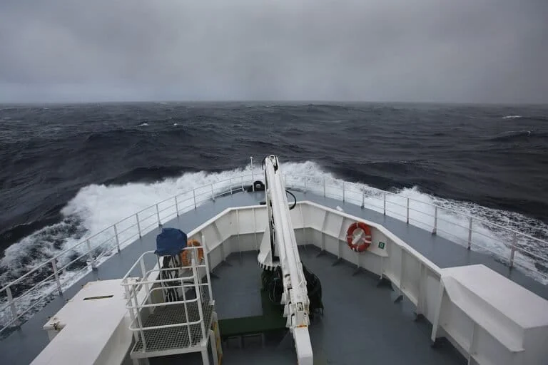
When a surfer carves through a wave at a break in Mentawai or a resident of Java’s southern coastline watches the tide roll in, the experience is rarely perceived as a distant atmospheric connection. Yet, the energy beneath those crests often originated thousands of miles away, birthed by the relentless, cyclonic fury of the Southern Ocean surrounding Antarctica. This vast, interconnected maritime system acts as a global engine, where the absence of landmasses allows wind to build into swells that traverse entire hemispheres, dictating conditions in tropical waters far removed from their icy origin.
The Mechanics of the Roaring Forties and Beyond
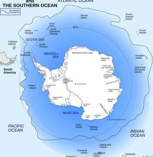
The geography of the Southern Hemisphere is fundamentally defined by the Southern Ocean, the only body of water on Earth that circles the globe without interruption by continents. At latitudes ranging between 40 and 60 degrees south, the "Roaring Forties," "Furious Fifties," and "Screaming Sixties" represent a meteorological phenomenon where wind speeds remain consistently high. In the Northern Hemisphere, landmasses like North America and Eurasia act as physical barriers, breaking up storm tracks and preventing the kind of unhindered wind-energy accumulation observed in the south.
The scientific concept of "fetch"—the distance over which wind blows in a constant direction—is maximized in the Southern Ocean. When a storm moves in sync with the waves it generates, the energy transfer is highly efficient. This creates waves that are not only immense in height but also possess long periods, allowing them to retain their kinetic energy as they transform into "swells." Once these waves move away from the high-energy storm centers, they can travel for thousands of kilometers across the Pacific or Indian Oceans with minimal dissipation. Consequently, a storm near the Antarctic Convergence can manifest as a powerful surf break in Indonesia several days later, creating the illusion of local weather patterns while actually reflecting a deep-sea event on the other side of the world.
Chronology of the 2018 Record-Breaking Event
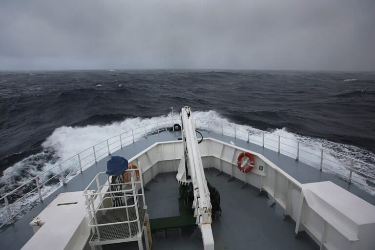
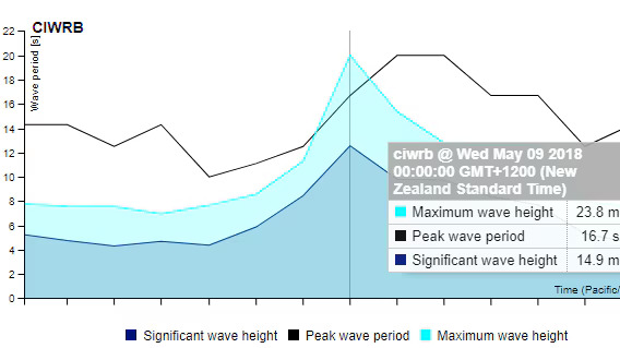
The power of this system was quantified in stark detail in May 2018. On May 9, a MetOcean Solutions buoy positioned roughly 700 kilometers south of New Zealand, near the remote Campbell Island, recorded a singular wave reaching 23.8 meters (approximately 78 feet). This measurement remains a critical benchmark in oceanographic science for the Southern Hemisphere.
The event was not a singular freak occurrence but the culmination of a massive, long-lived storm system moving eastward. Data from the buoy indicated that while the individual wave peak was 23.8 meters, the "significant wave height"—the average of the highest one-third of waves—was 14.9 meters. This distinction is vital for meteorologists and coastal engineers: a significant wave height provides a snapshot of the general sea state, while the maximum individual wave height accounts for the extreme spikes that occur due to constructive interference and local wind gusts. The duration of this event lasted several days, with the swell radiating outward across the Pacific, impacting coastal environments far to the north.
Comparative Analysis: Southern Ocean vs. North Atlantic
While the 23.8-meter record in the Southern Ocean is formidable, it does not hold the global title for the highest wave ever recorded. That distinction belongs to the North Atlantic. In February 2013, a buoy positioned between Iceland and the United Kingdom recorded a significant wave height of 19 meters, which is the current World Meteorological Organization (WMO) verified record. Furthermore, in February 2000, the research vessel RRS Discovery recorded a wave estimated at 29 meters in the Rockall Trough, west of Scotland.
However, oceanographers caution that these records may be skewed by the distribution of monitoring technology. The Southern Ocean is vastly more remote, with far fewer buoys, ships, and satellites providing high-fidelity, long-term data compared to the heavily trafficked shipping lanes of the North Atlantic. Experts argue that if the Southern Ocean were monitored with the same density of instrumentation as the North Atlantic, it is highly probable that even larger waves would be detected. The current data likely represents only a fraction of the true peak wave heights occurring in these deep-latitude waters.
Ecological and Climatic Implications
The influence of Southern Ocean waves extends well beyond the sport of surfing or the hazards faced by shipping vessels. These waves serve as a primary driver for the ocean’s vertical mixing. When these massive waves break, they physically churn the water column, forcing the nutrient-rich, cold waters of the deep to the surface and facilitating the exchange of heat and carbon dioxide between the atmosphere and the ocean.
As the planet faces shifting climate patterns, the role of the Southern Ocean as a massive "carbon sink" is under increased scrutiny. The intensity and frequency of storm tracks in the Southern Hemisphere are changing as global temperatures rise, which in turn alters the patterns of swells reaching equatorial regions. Furthermore, the local biodiversity is intricately linked to these turbulent conditions. Species such as the wandering albatross (Diomedea exulans) have evolved to exploit the unique physics of these seas. By utilizing the wind gradient—the difference in wind speed near the surface of a large wave compared to the air higher up—these birds can traverse thousands of kilometers with minimal energy expenditure, effectively "surfing" the atmosphere created by the ocean’s volatility.
Expert Perspectives and Future Monitoring
Oceanographers and meteorologists emphasize that the predictability of coastal conditions in the tropics is now inextricably linked to the monitoring of the high latitudes. Agencies like the WMO and regional meteorological centers are increasingly integrating satellite altimetry with fixed-buoy data to create more accurate wave-forecasting models. The realization that a serene day on a beach in Pacitan can be punctuated by "rogue" swells from a storm that occurred 8,000 kilometers away has shifted how local disaster management agencies view coastal safety.
Statements from the oceanographic community suggest that the current focus is on "event-based" monitoring. By tracking the life cycle of a storm from its genesis in the Antarctic circle, scientists can predict the arrival time, energy profile, and potential impact of the resulting swells on distant coastlines with increasing accuracy. This is not merely an academic exercise; for coastal communities in the Pacific and Indian Ocean basins, these predictions are essential for managing port operations, fishing activities, and coastal erosion mitigation.
Broader Impact on Global Systems
The study of these waves reveals a profound truth about the Earth’s interconnectedness. The Southern Ocean acts as a global conveyor belt for energy. The wind energy captured in the Antarctic circle is not lost; it is transported through the medium of water across the globe. Whether through the impact on climate regulation via gas exchange, the support of specialized migratory wildlife, or the shaping of tropical coastlines, the Southern Ocean remains one of the most influential, yet least understood, regions on the planet.
As monitoring technology advances, the scientific community anticipates that the next decade of research will yield a more granular understanding of how these wave patterns evolve. For now, the 2018 Campbell Island record serves as a potent reminder of the raw, untamed energy that resides at the bottom of the world—a force that, despite the vast distances involved, remains a constant companion to the lives of millions living along the world’s shores. Moving forward, continued investment in remote, autonomous ocean-monitoring technology will be the only way to ensure that we are not missing the larger, more powerful events that the Southern Ocean is undoubtedly capable of producing.