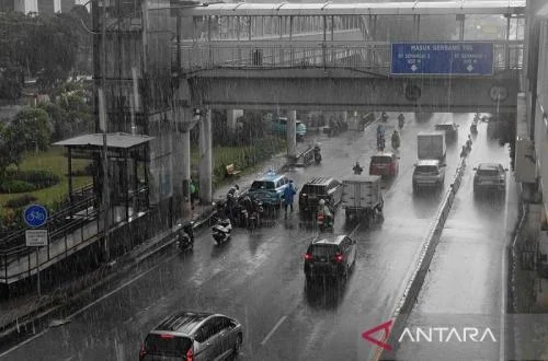
Jakarta, Indonesia – The Indonesian Agency for Meteorology, Climatology, and Geophysics (BMKG) has issued a comprehensive weather advisory for Tuesday, predicting a high potential for rainfall of varying intensities across numerous regions of the vast archipelagic nation. From light showers to torrential downpours accompanied by lightning, the forecast underscores the dynamic and often challenging weather patterns that characterize Indonesia’s tropical climate, prompting calls for heightened public vigilance and preparedness from both national and local authorities.
Indonesia’s Vulnerable Climate Landscape
Indonesia, situated along the equator and comprising over 17,000 islands, is inherently susceptible to diverse and often intense hydro-meteorological phenomena. Its geographical position exposes it to significant solar radiation and warm ocean currents, creating an environment conducive to high humidity and convective rainfall. The nation experiences two primary seasons: the wet season, typically from October to April, and the dry season, from May to September. However, these patterns can be influenced by global climate drivers such as the Madden-Julian Oscillation (MJO) and the El Niño-Southern Oscillation (ENSO), leading to variations in rainfall intensity and distribution. The current forecast falls squarely within the typical timeframe for the peak of the wet season, where intense, localized rainfall events are common, often leading to significant societal and environmental impacts. The BMKG plays a crucial role in monitoring these complex interactions, utilizing an extensive network of meteorological stations, radars, and satellite technology to provide timely and accurate forecasts vital for disaster mitigation efforts across the archipelago. The average annual rainfall in Indonesia varies significantly by region, but generally ranges from 2,000 mm to 3,000 mm, with some mountainous areas receiving upwards of 4,000 mm, highlighting the country’s naturally wet climate.
Detailed Regional Forecast Breakdown
According to BMKG forecaster Puji Sibuea, speaking during the agency’s morning weather briefing broadcast via its official YouTube channel, particular attention must be paid to areas expected to experience heavy to very heavy rainfall. This category of precipitation often exceeds 50 millimeters within a 24-hour period, posing substantial risks. Sibuea specifically highlighted Sumatera Utara (North Sumatra), Kepulauan Bangka Belitung (Bangka Belitung Islands), Banten, Jawa Tengah (Central Java), Sulawesi Barat (West Sulawesi), Sulawesi Tengah (Central Sulawesi), Maluku, Papua, Papua Tengah (Central Papua), and Papua Pegunungan (Highland Papua) as regions where communities must elevate their readiness for potential impacts. Such intense rainfall can rapidly saturate soil, overwhelm drainage systems, and cause rivers to swell, leading to flash floods and landslides, particularly in areas with undulating terrain or near river basins.
Beyond the immediate threat of heavy rain, the BMKG’s assessment also pinpoints several cities where thunderstorms are a significant concern. Thunderstorms, characterized by lightning, strong winds, and often intense but localized downpours, present unique hazards. The forecast indicates a high probability of thunderstorms in Tanjung Pinang, Pangkal Pinang, Palembang, Tanjung Selor, Banjarmasin, Palu, Mamuju, and Kendari. For eastern Indonesia, Sibuea specifically reiterated the warning for Palu, Mamuju, and Kendari, underscoring the potential for disruptive and dangerous weather events in these urban centers. Lightning strikes, a primary danger during thunderstorms, can cause fatalities, ignite fires, and damage electrical infrastructure. Strong winds accompanying these storms can also fell trees and damage property.
In contrast to the more severe warnings, many major cities across Indonesia are anticipated to experience lighter rainfall. This includes Banda Aceh, Medan, Pekanbaru, Padang, Jambi, Bengkulu, Bandar Lampung, Jakarta, Serang, Bandung, Semarang, Yogyakarta, Pontianak, Palangkaraya, and Samarinda. In the eastern part of the country, light rain is also forecast for Gorontalo, Manado, Ternate, Makassar, Sorong, Manokwari, Nabire, Jayapura, Jayawijaya, and Merauke. While less immediately threatening, even light rain can contribute to slippery roads and reduced visibility, necessitating caution for commuters and travelers.
Furthermore, the forecast includes areas with predominantly cloudy conditions. Surabaya is expected to experience thick cloud cover, while Denpasar, Kupang, and Mataram are predicted to have partly cloudy to thick cloudy skies. These conditions, while not directly hazardous, signify atmospheric moisture and potential for localized weather changes throughout the day.
Understanding the Mechanisms of Tropical Weather
The varying intensity of rainfall across Indonesia on any given day is a result of complex atmospheric dynamics. The Intertropical Convergence Zone (ITCZ), a belt of low pressure that encircles the Earth near the equator where the trade winds of the Northern and Southern Hemispheres converge, plays a significant role. As the ITCZ shifts seasonally, it brings intense rainfall to different parts of the archipelago. Additionally, local convective processes, driven by diurnal heating and the presence of moist air, frequently generate localized thunderstorms. Orographic lifting, where moist air is forced upwards by mountainous terrain, also contributes to heavy rainfall in highland regions. The presence of warm sea surface temperatures surrounding Indonesia fuels these processes, providing ample moisture and energy for cloud formation and precipitation. BMKG’s sophisticated modeling systems integrate data from various sources, including global numerical weather prediction models, regional climate models, and real-time observations from its vast network, to predict these intricate weather patterns. The agency continuously monitors atmospheric pressure, wind shear, humidity levels, and sea surface temperatures – critical parameters that influence cloud development and precipitation intensity.
Historical Context of Hydro-Meteorological Hazards
Indonesia has a long history of grappling with the severe consequences of hydro-meteorological disasters. Annually, the country faces numerous incidents of flooding and landslides, often triggered by intense rainfall. Major cities like Jakarta are particularly vulnerable to flooding due to their low-lying topography, high population density, and sometimes inadequate drainage infrastructure. Flash floods have devastated communities in various regions, including parts of Sumatra, Java, and Sulawesi, leading to significant loss of life, displacement of thousands, and extensive damage to property and infrastructure. Landslides are a recurring threat in hilly and mountainous areas, especially in West Java, Central Java, and Sulawesi, where deforestation and unstable soil conditions exacerbate the risks. For example, a single extreme rainfall event can trigger multiple landslides, isolating communities and disrupting essential services. The economic cost of these disasters runs into billions of rupiah each year, affecting agricultural output, tourism, and industrial activities. These historical patterns underscore the critical importance of BMKG’s warnings and the necessity for robust disaster preparedness and response mechanisms at all levels of government and within communities.
Implications for Public Safety and Infrastructure
The BMKG’s forecast carries significant implications for public safety and critical infrastructure across the targeted regions. For areas anticipating heavy to very heavy rainfall, the primary concerns are widespread flooding and landslides. These events can cut off transportation routes, destroy homes, and contaminate water sources, leading to potential health crises. Residents in flood-prone areas, particularly along riverbanks and coastal regions, are advised to prepare for potential evacuation. In mountainous and hilly regions, the risk of landslides necessitates vigilance, especially for those living on slopes or near deforested areas. The combination of saturated ground and continuous rainfall significantly increases the likelihood of soil movement.
Thunderstorms, while often localized, present immediate dangers. Lightning strikes are a leading cause of weather-related fatalities globally, and Indonesia is no exception. People are advised to seek shelter indoors, avoid open fields, and stay away from tall objects during thunderstorms. Strong winds associated with these storms can damage structures, bring down power lines, and disrupt maritime activities, posing risks to small boats and coastal communities. Furthermore, the overall increased rainfall can affect various sectors. Agriculture, a cornerstone of Indonesia’s economy, can suffer from crop damage due to flooding, impacting livelihoods and food security. Transportation, both land and air, faces disruptions due to reduced visibility, slippery roads, and potential infrastructure damage. Maritime travel can become hazardous due to rough seas and strong winds.
Official Responses and Preparedness Measures
In light of BMKG’s warnings, the National Disaster Management Agency (BNPB) and local Disaster Management Agencies (BPBDs) across the affected provinces are expected to intensify their readiness protocols. This typically involves activating emergency response teams, preparing evacuation shelters, and ensuring the availability of essential supplies. Local governments are crucial in disseminating information to communities, especially those in high-risk areas, and coordinating preparedness efforts. This includes clearing drainage systems, reinforcing vulnerable infrastructure, and conducting drills. Community leaders are often tasked with mobilizing volunteers and assisting residents, particularly the elderly and children, in preparedness measures. The collective response aims to minimize potential casualties and mitigate the economic and social disruption caused by adverse weather. Communication channels are vital during such periods, with authorities using various platforms, including traditional media, social media, and community alert systems, to keep the public informed.
The Role of Public Awareness and Information Dissemination
A critical component of disaster resilience in Indonesia is public awareness and access to accurate, timely information. BMKG’s Puji Sibuea underscored this point, urging the public to remain vigilant against the potential for extreme weather and to routinely update their weather information. The agency provides continuous updates through its official website (www.bmkg.go.id) and social media channels (@info.bmkg). This direct communication ensures that the public receives the most current forecasts and advisories, enabling them to make informed decisions regarding their safety and daily activities. "Ensure to always update weather information to anticipate the potential impacts of extreme weather," Puji emphasized. Public education campaigns on disaster preparedness, including understanding warning signs, developing emergency plans, and knowing evacuation routes, are ongoing efforts by both BMKG and BNPB. These initiatives are crucial for building a more resilient society capable of responding effectively to the inevitable challenges posed by Indonesia’s dynamic weather and climate.
Long-Term Climate Considerations
While the immediate focus remains on the daily forecast, the broader context of climate change looms large over Indonesia’s weather patterns. Scientific consensus indicates that global warming is likely to intensify extreme weather events, making heavy rainfall episodes more frequent and severe. Rising sea levels also exacerbate the impact of coastal flooding and storm surges. For an archipelagic nation like Indonesia, these long-term trends necessitate not only robust immediate response mechanisms but also strategic long-term adaptation and mitigation plans. Investing in climate-resilient infrastructure, promoting sustainable land use practices, and strengthening early warning systems are crucial steps in safeguarding Indonesia’s future against an increasingly unpredictable climate. The BMKG’s role extends beyond daily forecasting to long-term climate monitoring and research, providing essential data for policy-makers to develop these critical strategies. The agency continually collaborates with international bodies and scientific communities to enhance its predictive capabilities and contribute to global climate understanding.
As Indonesia navigates the complexities of its wet season, the BMKG’s persistent warnings serve as a vital call to action. From the densely populated islands of Java and Sumatra to the expansive, less-inhabited regions of Papua, preparedness and informed decision-making remain paramount in protecting lives and livelihoods against the relentless forces of nature.