Indonesia, an archipelago nation strategically positioned along the volatile Pacific Ring of Fire, faces an inherent and substantial seismic risk, highlighted by the 2024 Indonesia Earthquake Source and Hazard Map which identifies no less than 14 active megathrust zones encircling its vast expanse. This critical geological reality has drawn the attention of international experts, including Professor Kosuke Heki from Hokkaido University, a renowned geophysicist who, during his tenure as a Visiting Researcher at the National Research and Innovation Agency (BRIN) in late December 2025, underscored the striking similarities between Indonesia’s tectonic environment and the Nankai Trough, one of the world’s most seismically active megathrust regions located off the coast of Japan. Heki’s observations serve as a stark reminder of the immense potential for devastating seismic events across the Indonesian archipelago and the urgent need for enhanced monitoring and mitigation strategies.
Understanding Megathrust Zones and Indonesia’s Tectonic Setting
Megathrust zones represent the colossal interfaces where one tectonic plate is forced beneath another in a process known as subduction. These are the largest fault lines on Earth, capable of generating the most powerful earthquakes and tsunamis. Indonesia’s geographical position is particularly precarious, situated at the confluence of four major tectonic plates: the Indo-Australian Plate, the Eurasian Plate, the Pacific Plate, and the Philippine Sea Plate. The Indo-Australian Plate is actively subducting beneath the Eurasian Plate along the Sumatra, Java, and Sunda Arcs, creating a chain of highly active megathrust faults. Similarly, other plates interact around the eastern parts of Indonesia, contributing to its complex and dynamic seismic landscape. This relentless tectonic collision leads to immense stress accumulation over vast areas, which, when released, can result in catastrophic megathrust earthquakes, often exceeding magnitude 8.0, and triggering devastating tsunamis. The term "megathrust" itself signifies the immense scale and potential energy release from these fault systems, distinguishing them from ordinary crustal faults. The slow, continuous motion of these plates, typically a few centimeters per year, might seem insignificant on a human timescale, but over decades and centuries, it translates into significant crustal deformation and the build-up of elastic strain energy.
Insights from Professor Kosuke Heki: Learning from Japan’s Experience
Professor Heki, drawing parallels with the well-studied Nankai Trough, emphasized that Japan has historically experienced magnitude 8 earthquakes at intervals of approximately 50 to 100 years. This established recurrence interval, a classic understanding in Japanese seismology, provides a critical benchmark for assessing long-term seismic hazards. While acknowledging the inherent difficulty in precisely predicting the timing of major earthquakes – a challenge that continues to elude modern science – Heki stressed that long-term monitoring of Earth’s crustal deformation is paramount for effective disaster mitigation. His research, deeply rooted in the analysis of subtle ground movements, posits that continuous observation provides invaluable data for understanding the stress build-up within these fault systems. The Nankai Trough, for instance, has a documented history of producing powerful earthquakes at relatively regular intervals, often leading to widespread devastation. By comparing Indonesia’s geological characteristics and seismic patterns to those of the Nankai Trough, Heki suggests that Indonesia could be subject to similar large-scale, periodic seismic events, necessitating a proactive and sophisticated approach to hazard assessment. The scientific community worldwide largely agrees that while pinpointing the exact date and time of an earthquake remains impossible, understanding the probability and potential magnitude of future events through long-term monitoring is crucial for preparedness.
Leveraging Advanced Monitoring Technologies: GNSS and Seafloor Geodesy
The core of Professor Heki’s recommendations lies in the robust application of advanced geodetic techniques, particularly the Global Navigation Satellite System (GNSS) and seafloor geodetic measurements. GNSS, which includes systems like GPS, GLONASS, Galileo, and BeiDou, utilizes signals from satellite constellations to precisely measure changes in the Earth’s surface position with millimeter-level accuracy. A dense network of continuously operating GNSS stations across Indonesia’s active fault zones can meticulously track the subtle, ongoing deformation of the Earth’s crust. This data allows scientists to infer the rate and direction of strain accumulation, providing critical insights into which segments of a fault are locked and accumulating stress.
Beyond land-based GNSS, Heki highlighted the critical role of seafloor geodesy. Many of Indonesia’s most dangerous megathrust zones are located offshore, making direct land-based measurements insufficient. Seafloor geodetic instruments, such as acoustic transponders placed on the ocean floor, can precisely measure horizontal and vertical movements of the seabed relative to surface vessels equipped with GNSS receivers. This technology is vital for reading the accumulation of tectonic stress directly within the subduction zones, particularly along the shallow parts of the plate boundary where much of the energy for large tsunamis is generated. By measuring these subtle shifts over extended periods, scientists can identify segments of the fault that are "locked," meaning they are accumulating elastic strain without slipping.
Heki further elaborated on the concept of "seismic coupling," explaining that nearly along the entire axis of these oceanic trenches, there is an interlocking between the subducting and overriding plates. This coupling implies that even in the very shallow parts of the plate boundary, significant strain continues to accumulate for future earthquakes. This accumulated strain represents the stored energy that will eventually be released as a seismic event. Without these advanced measurement techniques, understanding the precise location and extent of these locked segments and the rate of strain accumulation would be far more challenging, hindering accurate hazard assessments.
The Phenomenon of Slow Slip Events (SSEs)
Another critical phenomenon highlighted by Professor Heki is "slow slip events" (SSEs). Unlike conventional earthquakes that involve rapid, brittle rupture of the fault over seconds or minutes, SSEs are characterized by gradual, aseismic (non-earthquake generating) slip along a fault that can last for days, weeks, or even months. While they do not generate destructive seismic waves, SSEs release accumulated stress slowly. Crucially, they are often observed to precede large megathrust earthquakes, making them potential early indicators of impending major seismic activity. Detecting SSEs requires highly sensitive and continuous geodetic measurements, such as those provided by advanced GNSS networks and seafloor geodesy. The presence and characteristics of SSEs can provide scientists with valuable information about the state of stress on a fault and its readiness to rupture, offering a potential window for enhanced preparedness.
Indonesia’s Opportunity for Enhanced Seismic Monitoring
Given its extensive network of active subduction zones – stretching from Sumatra, Java, Bali, and Lombok to Maluku – Indonesia possesses an unparalleled opportunity to develop a sophisticated, state-of-the-art seismic monitoring system. Heki explicitly stated that Indonesia has the potential to strengthen its GNSS network significantly, enabling more precise readings of tectonic stress accumulation across its diverse and active fault systems. This enhancement would not only contribute to a deeper scientific understanding of Indonesia’s seismotectonics but also lay the groundwork for a more effective early warning and disaster mitigation framework. The commitment of international experts like Heki, who affirmed, "Currently I am working on this problem in Indonesia," underscores the global scientific community’s recognition of Indonesia’s critical need and potential in this field. Collaborative efforts between Indonesian institutions like BRIN and BMKG with international partners can accelerate the deployment and utilization of these advanced technologies.
Key Megathrust Zones and Their Devastating Potential
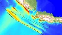
The 2024 Indonesia Earthquake Source and Hazard Map pinpoints several megathrust zones with alarming potential. Among them, the Aceh-Andaman megathrust stands out with the highest maximum potential magnitude, reaching M9.2. This zone gained global notoriety in 2004 when it ruptured, generating the colossal M9.1-9.3 Indian Ocean earthquake and tsunami, one of the deadliest natural disasters in recorded history, claiming over 230,000 lives across 14 countries, with Indonesia, particularly Aceh, bearing the brunt of the devastation. The memory of this event serves as a grim reminder of the immense power held within these geological structures.
Another critical zone is the Java megathrust, which has a potential maximum magnitude of M8.9. This segment, running along the southern coast of Java, is densely populated and hosts vital economic infrastructure, making any major rupture a scenario with catastrophic implications. The potential for a large earthquake here, possibly generating a destructive tsunami, poses an existential threat to millions of people residing in coastal areas along Java.
Beyond these, other megathrust zones off Sumatra, Bali, Lombok, and Maluku also carry significant potential for large earthquakes and tsunamis, each with its own specific characteristics and hazard profile. For instance, the Mentawai segment off Sumatra is known for its high seismic hazard and the presence of significant seismic gaps.
Seismic Gaps: Accumulating Energy, Not Predicting Imminence
The Indonesian Agency for Meteorology, Climatology, and Geophysics (BMKG) has specifically highlighted two megathrust zones currently identified as being in a "seismic gap" condition: the Sunda Strait and Mentawai-Siberut. A seismic gap refers to a segment of an active fault that has not experienced a major earthquake for a long period, relative to other segments of the same fault or to its historical recurrence interval. This suggests that stress might be accumulating there, making it a candidate for a future large earthquake.
The Sunda Strait megathrust has not released significant energy through a major earthquake since 1757, marking an exceptionally long period of quiescence. Similarly, the Mentawai-Siberut segment, off the coast of West Sumatra, has been quiescent since 1797. These extended periods without large ruptures indicate that these fault segments are likely accumulating significant amounts of elastic strain energy.
However, BMKG was quick to clarify the meaning of "waiting time" in this context. They emphasized that this term does not constitute a prediction of when an earthquake will occur. Instead, it refers to the "accumulation of energy that is still stored because a large earthquake has not occurred for a long time." This crucial distinction prevents misinterpretation and avoids inducing panic, as the scientific community consistently reiterates that current technology cannot predict earthquakes with precision regarding time, location, and magnitude. The concept underscores the heightened risk and the need for preparedness due to the sustained build-up of tectonic stress.
Historical Context of Indonesia’s Seismic Activity
Indonesia’s history is punctuated by devastating earthquakes and tsunamis. The 2004 Indian Ocean earthquake off Aceh, as mentioned, stands as a stark reminder. Following this, the M8.6 Nias earthquake in 2005, the M7.7 Java earthquake and tsunami in 2006, the M7.6 Sumatra earthquake in 2009, and more recently, the series of powerful earthquakes in Lombok and Palu in 2018, and the Anak Krakatau tsunami in the Sunda Strait, all underscore the nation’s profound vulnerability. Each event has provided invaluable, albeit tragic, lessons in seismology, disaster response, and urban planning. These historical occurrences reinforce the urgency of implementing robust monitoring and mitigation strategies, as the past is a strong indicator of future potential for seismic activity in the region. The tectonic forces at play are constant, and the question is not if, but when and where, the next major release of energy will occur.
Comprehensive Mitigation and Future Outlook
Indonesia’s strategy for addressing its seismic vulnerability must be multi-faceted, integrating scientific research, technological advancement, policy implementation, and community preparedness. The collaboration with international experts like Professor Heki, facilitated by institutions such as BRIN, is vital for transferring knowledge and implementing cutting-edge monitoring technologies. Strengthening the existing GNSS network, deploying more seafloor geodetic instruments, and developing advanced data analysis capabilities are crucial first steps.
Beyond monitoring, effective disaster mitigation requires:
- Robust Early Warning Systems: While predicting earthquakes remains elusive, tsunami early warning systems, triggered by seismic events, are critical for saving lives in coastal areas. These systems rely on rapid seismic data analysis and ocean buoy networks.
- Infrastructure Resilience: Implementing and enforcing strict building codes for earthquake-resistant structures, particularly in high-risk zones, is paramount. This includes critical infrastructure like hospitals, schools, and transportation networks.
- Spatial Planning: Revising urban planning to avoid constructing critical facilities and high-density residential areas in zones highly susceptible to ground shaking, liquefaction, landslides, or tsunami inundation.
- Public Education and Preparedness: Continuously educating the public on earthquake and tsunami safety protocols, including evacuation routes, emergency kits, and "drop, cover, hold on" drills, is fundamental. A well-informed populace is a resilient populace.
- International Cooperation: Fostering continued collaboration with global seismic research institutions, sharing data, and participating in joint research initiatives will enhance Indonesia’s capacity to understand and respond to seismic hazards.
Broader Implications
The implications of potential megathrust earthquakes in Indonesia extend far beyond immediate loss of life and infrastructure damage. Economically, major seismic events can cripple key industries, disrupt supply chains, and deter investment, impacting national and regional development for years. Socially, mass displacement, psychological trauma, and the disruption of community structures can have profound long-term effects. Environmentally, tsunamis can alter coastlines, destroy ecosystems, and contaminate water sources. Thus, proactive measures are not merely about saving lives but also about safeguarding the nation’s sustainable development and future prosperity. The ongoing research and investment in seismic monitoring and mitigation are not expenses but essential investments in national security and resilience.
In conclusion, Indonesia’s position at the heart of global seismic activity necessitates an unwavering commitment to understanding and preparing for future megathrust events. The insights from experts like Professor Kosuke Heki, coupled with the potential of advanced technologies such as GNSS and seafloor geodesy, offer a pathway toward a more resilient future. While the exact timing of the next great earthquake remains unknown, the continuous accumulation of energy in seismic gaps like the Sunda Strait and Mentawai-Siberut underscores the critical importance of preparedness, making long-term monitoring and comprehensive mitigation strategies not just advisable, but absolutely imperative for the safety and stability of the Indonesian nation.